By Cory Harris and Norm Miller
One year ago, on a sunny, holiday Monday (for most of Southern Ontario), Burlington was hit by a storm which dropped large amounts of rain in a short period of time. This storm delivered up to 192 mm of rain in total according to one rain gauge on Palmer Avenue (near Walker’s Line), while just minutes away in the Tyandaga area (near Brant Street and Dundas Street), rain gauges recorded 48 to 54 mm of rain.

Affected Areas of Burlington from the August 4th, 2014 Flood
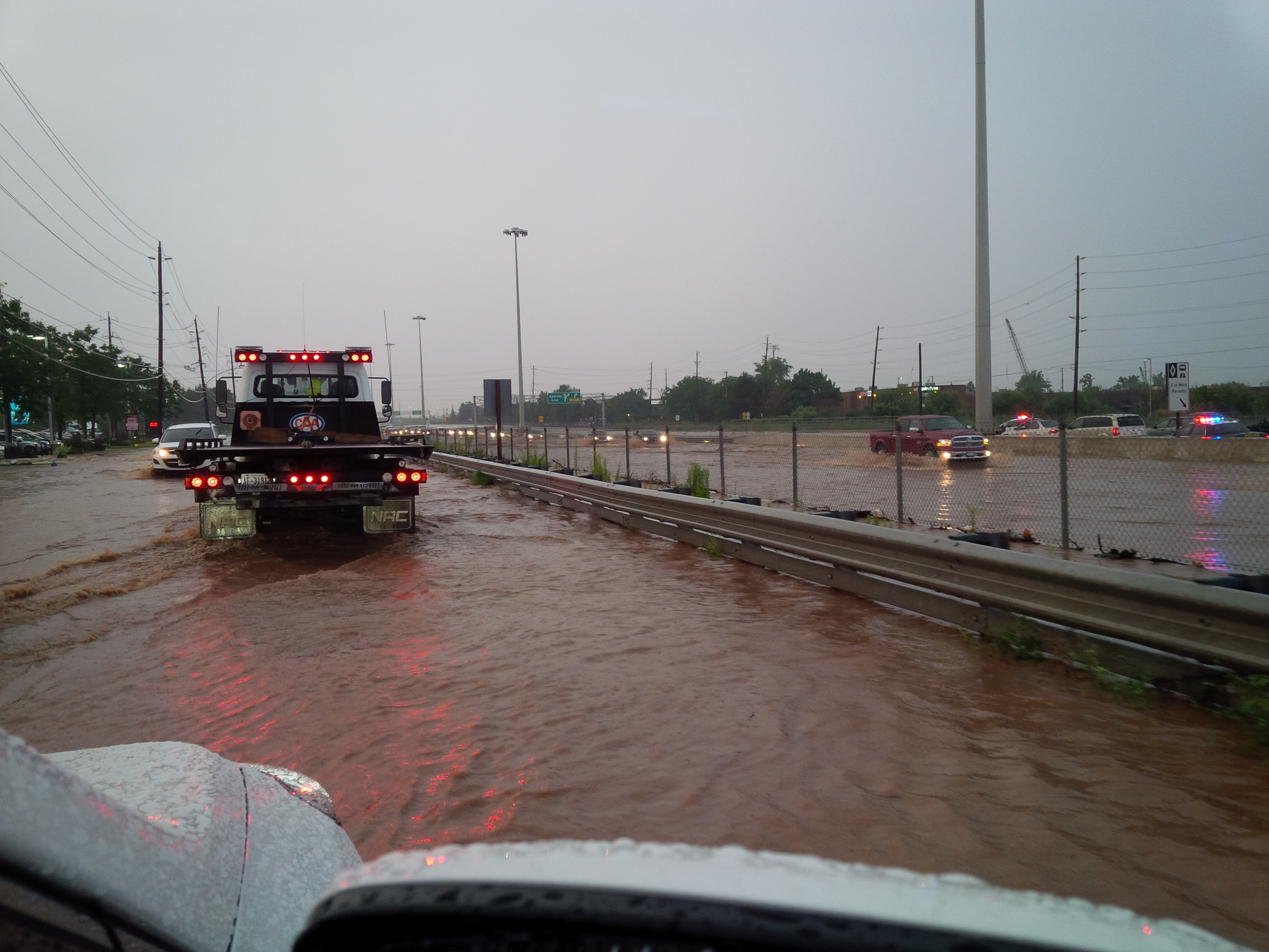
The August 4, 2014 storm rolled through in two waves, the first just before 2 p.m. with the rain lasting for only a few minutes, and the second saw rain fall in varying amounts between 3 and 7 p.m. The storm extended from roughly Mountsberg Road in the north to Lake Ontario in the south, Burloak Drive in the east, and Brant Street in the west. The elliptically shaped area had a length of approximately 25 km and a width of approximately 9 km, with the storm area being approximately 200 km². The watercourses most impacted were Tuck Creek, Shoreacres Creek, and Appleby Creek.
Due to the intensity, the storm generated significant runoff in a short period of time (flash flood) which flooded homes, businesses, parks, overtopped watercourse crossings, closed roads, and flooded motor vehicles.

Itabashi Bridge
The August 4, 2014 storm was a severe weather event and is typical of the storms we are beginning to see more of recently. These storms can pop up quickly and are shorter in duration and more intense in terms of rainfall. They can also be highly localized as evidenced by our rain gauge data.

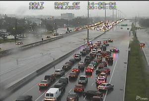
North Service Road, QEW, August 4th, 2014, Burlington
As part of our flood forecasting and warning service, Conservation Halton issued flood warning messages, monitored weather and river conditions, and issued updates as necessary to the City of Burlington, emergency services and the media. These organizations then take the necessary action to protect the public, for example closing roads which are flooding or alerting people in their homes.
The following day (Tuesday, August 5), after the storm had ended, Conservation Halton staff began conducting field investigations in areas of the City of Burlington affected by riverine (creek-based) flooding to document damages and the extent of flooding. The investigation took staff the better part of a week as they examined debris patterns, high water marks and spoke to residents in areas near creeks and streams.
It is very important to understand how the watershed responds during a severe storm event in order to guide future development and improve flood plain management. Conservation Halton staff put together a detailed report, in consultation with Halton Region and the City of Burlington, which was presented to the Conservation Halton Board of Directors in April and released to the public on May 1st. The complete report can be found on the Conservation Halton website at www.conservationhalton.ca/burlingtonflood.
The most important finding, with further details available in the Flood Report, is that the areas in the City of Burlington where Provincial and Conservation Halton flood plain planning policies were applied during development, were the least affected during the August 4, 2014 Storm event. These areas (typically developed after the mid 1970’s) experienced the least amount of erosion and flood damage in comparison to areas of the City of Burlington that were developed before these policies were put into place. Proper planning, which involves not putting people and property in potential harm’s way, is Conservation Halton mandate, which we have been providing to the community for the past 40 years. Conservation Halton staff work hard to address natural hazards through the application of science-based regulation and planning policies.
Conservation Halton’s Burlington Flood Report also contains four recommendations based on the experience from the flood. These recommendations identify the need for better protection measures for Burlington from the effects of future storms, and also identify the need to improved monitoring and the sharing of information.
It is also important to draw a distinction between urban versus riverine flooding. Urban flooding can be defined as nuisance flooding of streets, underpasses, basements and other low-lying urban areas usually due to poor drainage or limited drainage capacity of urban systems (i.e. stormwater). Riverine (creek-based) flooding is flooding that occurs when surface runoff causes a river to swell causing the water to breach the river’s banks. The water then overflows into the river’s flood plain area(s).Conservation Halton is responsible for riverine flooding which is where our flood plain mapping and regulations come in to play. These maps help determine where development can occur and keep people out of harm’s way.
Conservation Halton and Natural Hazards
Natural events that can pose a threat to humans, their property, or the environment are given the term ‘natural hazards’. Natural hazards are often equated with extreme rainfall or snowmelt, fog events, snow/ice storms, forest fires, tornadoes, and earthquakes but the term can also include flooding and erosion associated with creek and river systems.
Conservation Halton has two primary roles when it comes to flooding. The first is flood protection through a water control and flood warning program. Water control is in the form of dams (Hilton Falls, Kelso, Mountsberg and Scotch Block) and flood control channels (Milton, Morrison-Wedgewood and Hager-Rambo) which effectively hold back and divert water from flood prone areas during storms. Flood duty staff monitor weather forecasts from Environment Canada, local weather conditions, and water levels. When flooding is possible or about to occur, Conservation Halton issues flood warning messages to municipal emergency management officials and the media. The municipal officials would then take action to warn local residents. Flood warning messages fall under three categories.
The second role Conservation Halton plays is natural hazard management as part of the land use planning process. This service supports development decisions which safeguard human life and property while protecting the natural features of our watershed. Conservation Halton’s Watershed Management Services Division review development proposals to determine how the proposed works may impact upon, and/or be impacted by, natural hazards. Conservation Halton has the regulatory responsibility to ensure that development is not permitted in areas of natural hazards in order to prevent the loss of life and property. Key in this is preventing home construction and other development projects within ravines, flood plains, shorelines, wetlands, etc.
Conservation Halton’s Regulations, which guide development in and around creeks and watercourses, are intended to keep people and property from natural hazards such as flooding and erosion, and protect against creek or riverine flooding. They are intended to safeguard against the effects of a Regional Storm, such as Hurricane Hazel, which struck Southern Ontario on October 15, 1954.A Regional Storm is the standard to which Conservation Halton regulates. Hurricane Hazel pounded the Toronto region with winds that reached 110 kilometres per hour (68 mph) and 285 millimetres (11.23 inches) of rain in 48 hours, killing 81 people in the process. The damage impacts of Hurricane Hazel cost taxpayers more than $1 Billion in today’s dollars. See www.hurricanehazel.ca for more information.
The work that Conservation Halton does keeps people and property safe from natural hazards such as flooding and erosion and also provides a significant benefit to taxpayers by preventing loss of life and damage to property. The Conservation Authority model is unique to the Province of Ontario and is one of the only natural hazards management models that emphasize prevention and sound planning as the key elements in encouraging development that is in synergy with the natural environment when it comes to natural hazards.